|
|
 |
| |
Home > Chapter IX
|
|
Chap IX. Climate change and natural disasters
|
Rwandas climate
|
Climate is the average prevailing weather conditions for a specific geographical region over a period usually exceeding 30 years. Due to its high altitude, Rwanda enjoys a tropical temperate climate. The average annual temperature ranges between 16 and 20°C, without significant variations. Rainfall is abundant although it has some irregularities. Winds are generally around 1-3 m/s (Twagiramungu 2006). With an economy heavily dependent on rain fed agriculture, climate is of particular importance.
Temperature
Rwandas average temperature varies according its topography. Low temperatures are observed in the regions of high altitude with average temperatures ranging between 15 and 17°C. In some parts of the volcanic region, temperatures can go below 0°C. Moderate temperatures are found in areas with intermediary altitude where average temperatures vary between 19 and 21°C. In the lowlands (east and southwest), temperatures are higher and the extreme can go beyond 30°C in February and July-August. Figure 1 shows the temperatures across the country in relation to topography (Twagiramungu 2006).

Rainfall
The rainfall patterns are characterized by four seasons, a short rainy season from September to November and a longer season between March and May. Between these seasons are two dry periods, a short one between December and February and a long one from June to August. Rainfall ranges from about 900 mm in the east and southeast to 1500 mm in the north and northwest volcanic highland areas.
The rainfall is generally well distributed throughout the year, with some spatial and temporal variability. Eastern and southeastern regions are more affected by prolonged droughts while the northern and western regions experience abundant rainfall that at times cause erosion, flooding and landslides. The spatial variability has been attributed to the complex topography and the existence of large water bodies within the Great Lakes Region.
|
Climate change in Rwanda
|
The meteorological stations that are currently operational are not representative enough to provide a true picture of climate variability. However, observations and analysis from existing data shows that over the last 30 years, some parts of Rwanda have experienced unusual irregularities in climate patterns including variability in rainfall frequencies and intensity, persistence of extremes like heavy rainfall in the northern parts and drought in the eastern and southern parts.
Variability in rainfall
Analysis of rainfall trends show that rainy seasons are tending to become shorter with higher intensity. This tendency has led to decreases in agricultural production and events such as droughts in dry areas; and floods or landslides in areas experiencing heavy rains. Heavy rains have been being observed especially in the northern and the western province. These heavy rains coupled with a loss of ecosystems services resulting from deforestation and poor agricultural practices have resulted in soil erosion, rock falls, landslides and floods which destroy crops, houses and other infrastructure (roads, bridges and schools) as well as loss of human and animal lives.
On the other hand the eastern region of the country has been experiencing rainfall deficits over the last decades. Observations between 1961 and 2005 showed that the period between 1991 and 2000 has been the driest since 1961. These observations showed a marked deficit in 1992, 1993, 1996, 1999 and 2000 with rainfall excesses in 1998 and 2001 (MINITERE 2006).
The data shows that total annual precipitation during 2006 was higher than the average precipitation over the previous 30 years which implies a tendency towards increased precipitation (MINITERE 2006). This tendency was observed from three meteorological stations (Kigali, Kamembe (southwest) and Gisenyi (northwest).
Variability in temperature
Observations show an increase in the average temperature in Rwanda over the last twenty years. This is shown in figure 2. Data for 2006, showed that temperatures were higher than the 32-year average for the dry seasons (January, February, July, August, September and October) and were lower than the 32-year average temperatures for the rainy seasons (March, April, May, November and December) (MINITERE 2006).

|
Vulnerability to Natural disasters
|
With its geographical location in the East African Rift Valley near the Nyiragongo volcanoes and the effect of the Inter Tropical Convergence Zone (ITCZ) on the continent, Rwanda is vulnerable to natural disasters emanating from climatic or seismic disturbances. Some of these disasters include drought, torrential rains, floods, landslides, earthquakes, volcanic eruptions and epidemics. In the past 10 years, these disasters have practically occurred throughout the country. Such disasters are exacerbated by poor farming practices, deforestation and environmental degradation among others.
Even though disasters experienced in Rwanda are not always linked to climate change, a single disruption of the usual climatic trend leads to terrible consequences due to the over-reliance on agriculture in a context of overpopulation.
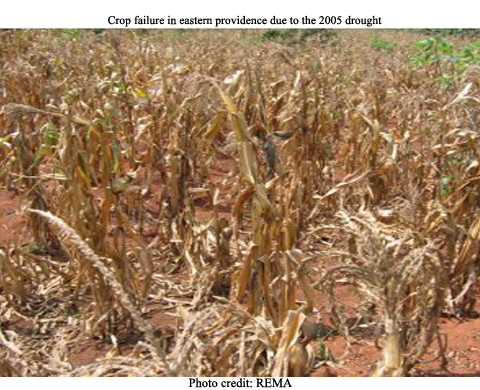
Droughts
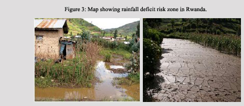
Figure 3 shows the rainfall deficit risk zone of Rwanda. It includes Bugesera, Nyagatare, Gatsibo, Kayonza, Ngoma and Kirehe districts in the eastern province and the eastern parts of Nyanza and Gisagara districts in southern province. These districts are characterized by high frequency of rainfall deficit, late rainfall onsets, early rainfall cessations, a significant number of dry spells and are prone to drought
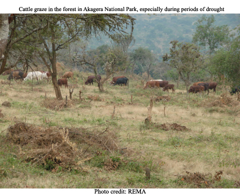
Prolonged droughts are frequent in the east and southeast such as Bugesera, Mayaga and Umutara. They tend to be cyclical and can be persistent. Droughts are often responsible for famine, food shortages, a reduction in plant and animal species and displacement of people in search of food and pasture. At times this has led to conflicts over different land uses such as with protected areas. For instance drought has on several instances forced herders to move their herds from Mutara closer to or into the Akagera National Park during the dry season (Chemonics International Inc 2003). Box 1 highlights some of the impacts of drought in Bugesera.
|
Box 1: Impacts of drought in Bugesera
Bugesera experienced severe droughts in 1999, 2006 and more recently in November 2008. The livelihoods of people in Bugesera are dependant on agriculture. So long dry spells have great impacts on their livelihoods and welfare. Crop failure during the 2000 drought meant that the entire region had to depend on external food supplies. The length and intensity of land degradation have also weakened the lands resilience. When combined with overgrazing and poor cultivation practices, drought has led to deterioration in pasture and arable land to the point where they have been abandoned. Changing climatic conditions has been associated with declining food crop production due to low moisture content. Cassava, the main food and income-generating crop is now a rare commodity; and the production of beans has also been negatively affected by the low soil moisture.
Little effort has been made to mitigate the problems of rainfall unpredictability. There is an emergence of pests and diseases, possibly because of changing environmental conditions, crop pests were reported to have increased.
Source: WFP/FEWS-NET 2003, REMA 2007.
|

Floods
Heavy rainfall, in combination with natural factors like topography, is having great impact in some areas. Floods and landslides are the main disasters in the high altitude regions mainly during the rainy seasons. Indeed in light of Rwandas topography, the potential for flash flooding in many parts of the country is ever present.
The results of human activities (poor farming practices, deforestation and environmental degradation) have aggravated the impacts of floods on people, agriculture and the physical infrastructure. The flood and landslide risk zones derived from the analysis of frequencies of daily rainfall exceeding 50 mm, are located in the southern, northern and western province (MINITERE 2006). These zones have been largely deforested, and now experience heavy rains which have caused extensive flooding and landslides, rock falls, soil erosion, destruction of crops, houses and infrastructure (roads, bridges and schools) as well as losses of human and animal lives. Cases of floods and landslides are often associated with outbreaks of water-borne and water-related diseases like malaria, diarrhea, cholera and viral infections mainly through the contamination of wells and ground water. Box 2 describes some of the impacts caused by the decline in Gishwati forest and figure 4 shows satellite imagery of the changes in forest cover.
In September 2008 the heavy rains and winds adversely affected 8 among 12 sectors of Rubavu district: Gisenyi, Rubavu, Rugerero, Nyamyumba, Nyundo, Cyanzarwe, Nyakiriba and Kanama.
|
Box 2: Floods in Gishwati forests
Like in any other tropical forests, Gishwati forests helps maintain soil quality, limit erosion, stabilize hillsides and modulate seasonal flooding. It has also protected down stream water resources from accelerated siltation. The loss of the forest in many areas has resulted in tremendous environmental consequences such as accelerated soil erosion and consequent direct loss of agricultural productivity of the farmers. This ecological function is particularly important to the poorest people who rely on natural resources for their everyday survival. Degradation has also led to more floods in Gishwati and electricity shortage in Cyangugu due to siltation of Sebeya River. The rehabilitation and remediation cost of Gishwati is estimated at US$ 3.6 million. Agricultural loss due to degradation was estimated to be up to RWF 120,000 for the next harvesting season. The overall cost of activities to partly rehabilitate Gishwati is estimated at RWF 2 billion for 5 years.
Source: REMA 2006.
|
Earthquakes
Rwanda is located in a tectonic region whose epicentre is located in Lake Kivu. The northwest part of the country is occupied by a volcanic chain that is seismically active. This location makes Rwanda, especially the western region, susceptible to earthquakes.
Indeed recently, two earthquakes of magnitude 6.1 and 5.0 and subsequent aftershocks occurred on 3rd and 14th February 2008 respectively. The epicentre of these earthquakes was located close to the Kivu lakeside city of Bukavu in the Democratic Republic of Congo (see figure 5). These earthquakes affected seriously Rusizi and Nyamasheke districts where 37 people died and 643 were injured. In addition 1,201 families lost their homes and 20 primary and 4 secondary schools were damaged. According to the government, 212 classrooms require reconstruction and an additional 113 need to be repaired. The hospital of Bushenge was also badly affected (OCHA 2008).

Volcanic eruptions
The volcanic chain in the northwest, including the Nyiragongo located in Democratic Republic of Congo, is still active and frequently erupts. This volcanic activity is a hazard for the inhabitants of the Goma and Gisenyi regions in the Democratic Republic of Congo and Rwanda, respectively.
The most recent eruption in August 2005 caused infrastructure damage in Goma city in Democratic Republic of Congo which borders Gisenyi city in Rubavu district. A major eruption began at Nyiragongo volcano on 17th January 2002 with lava flows reaching Goma. About 15 per cent of the town especially the commercial area and much of the water and electricity supply was destroyed by the lava flows and resulting fires. The lava flows triggered a massive exodus of the population from Goma, some going southwards inside DRC towards Saké, but the majority - perhaps up to 400,000 people - fled across the adjacent border into Rwanda in the vicinity of Gisenyi (IFRC 2002).
|
Responses
|
Adaptation to climate change
The majority of the Rwandan population relies on rain fed agriculture for their livelihoods, and the impacts of variability in climate patterns are already being felt. There are thus opportunities for improved food security, water availability and livelihoods if programmes to assist with adapting to climate change are implemented. Rwanda is a signatory to the United Nations Framework Convention on Climate Change (UNFCCC) and to the Kyoto Protocol. In the framework of implementation of the convention but also in order to reduce the damage from disasters arising from the impacts of climate change, Rwanda has identified the following six priority areas for adaptation to climate change:
- Integrated Water Resource Management (IWRM);
- Setting up an information system for early warning of hydrological and agro-meteorological systems and rapid intervention mechanisms;
- Promotion of intensive agro-pastoral activities;
- Promotion of non agricultural income generating activities;
- Introduction of species resistant to extreme conditions;
- Development of alternative sources of energy to firewood.
Mechanisms to reduce vulnerability to disasters
Mechanisms to address disasters have mainly focused on mobilization and distribution of relief to populations affected by specific disaster events. The key elements of disaster management namely prevention, preparedness, assessment, mitigation and disaster reduction are now being given due attention. In this regard, a Disaster Management Coordination Unit (DMC) was established by the Cabinet Meeting of 27th October 2004 and Disaster Teams at district and sector levels were put in place in 2007. The Disaster Management Coordination Unit is under the national police and has the following mandate:
- Assess and evaluate disasters frequently observed in districts or sectors,
- Prepare disaster management programmes including disaster mitigation,
- Assess and evaluate disaster socio-economic cost,
- Report to Disaster Management Coordination (Prime Ministers office)
The Disaster Management Coordination Unit has carried out disasters risk assessments studies in the sensitive parts of the country, especially in the northern, western and southern parts of the country.
There is an ongoing monitoring of volcanic activity by a team of volcanologists of the Goma Volcano Observatory together with the National University of Rwanda. However, this activity needs more human and financial means to be able to monitor the Nyiragongo volcano and to disseminate or diffuse the research results and to have sufficient early warning systems.
Monitoring of meteorological parameters is also currently being given prominence. The few existing meteorological monitoring stations are run down due to a lack of maintenance and expertise to track changing climatic conditions. The country also does not have an operational observatory network to facilitate adequate understanding of the national climate conditions and lacks the ability to predict local climate change. Therefore the government plans to gradually strengthen its meteorological service by adopting and implementing a meteorological policy and strategy, establishing an upper air observatory and establishing an atlas on the spatial and temporal distribution of rainfall, temperature and humidity over Rwanda by 2012 (ROR 2007).
|
Conclusions and recommendations
|
Climate plays a central role in agriculture which is the main stay of the Rwandan economy and community livelihood. However, due to anthropological activities, climate change is becoming a reality. Climate-related events like heavy rainfall or too little rainfall are becoming more frequent and are impacting on human wellbeing. These culminate into disasters like torrential rains drought, torrential rains, floods, landslides, earthquakes, volcanic eruptions and epidemics.
Prediction and early warning information and products are vital to the management, risk reduction and mitigation of disasters. Awareness-raising is important so that people know how to reduce risk and harm caused by the various disasters or other precautionary and mitigation measures.
The Rwanda Meteorological Service does not have enough capacity to deliver sufficient data, information and advisories due to the lack of sufficient qualified personnel, inadequate observing station network and sufficient data processing equipment. The government is working on programmes to enable adaptation to some of the impacts of climate change. At the same time it has set up mechanisms to reduce vulnerability to disasters. It should soon be in position to monitor and issue forecasts well in advance for adequate preparation and handling of disasters.
In order to improve on prediction and early detection of extreme meteorological and hydrological events, and of climate variability and change, proper understanding of the processes that control global weather and climate systems is required. These processes include weather prediction research at all time scales, modelling and downscaling capacity, especially the potential to improve the prediction of climate variability or change at local level to be factored into disaster management and disaster risk reduction.
|
References
|
- Chemonics International Inc (2003). Rwanda Environmental Threats And Opportunities Assessment. Task Order No. 818 under the Biodiversity & Sustainable Forestry (BIOFOR) IQC USAID Contract No. LAG-I-00-99-00014-00. Also available on: http://www.encapafrica.org/documents/biofor/Rwanda_2003.pdf
- IFRC (2002). Democratic Republic of Congo and Rwanda: Volcanic Eruption In Goma Appeal No. 02/02 Final Report. 16 Dec 2002. International Federation Of Red Cross And Red Crescent Societies (IFRC). Also available on http://www.ifrc.org
- Kalisa, J (undated). The effects of climate change in Rwandan region. Global Campus 21. Internationale Weiterbildung und Entwicklung gGhmH (inWent). Also available on: .www.gc21.de/ibt/alumni/ibt/docs/writoec-john-kalisa.pdf
- MININFRA (2004). Generation and application of climate information, products and services for disaster preparedness and sustainable development in Rwanda. Ministry of Infrastructure, Department of Meteorology (MININFRA), Kigali
- MINITERE (2006). National Adaptation Programmes of Action (NAPA) To Climate Change. Ministry Of Lands, Environment, Forestry, Water and Mines (MINITERE), Kigali.
- OCHA (2008). Earthquake in the Great Lakes Region. OCHA Situation Report 15 Feb 2008. United Nations Office for the Coordination of Humanitarian Affairs (OCHA).
- ROR (2007). Economic Development And Poverty Reduction Strategy, 2008-2012. Ministry of Finance and Economic Planning, Republic of Rwanda (ROR), Kigali.
- REMA (2007). Pilot Integrated Ecosystem Assessment of Bugesera. Poverty Environment Initiative (PEI) implemented by the United Nations Development Programme (UNDP), United Nations Environment Programme (UNEP) and Rwanda Environment Management Authority (REMA), Kigali.
- Twagiramungu, F. (2006). Environmental Profile of Rwanda. European Commission, Kigali.
- WFP/FEWS-NET (2003). Rwanda Vulnerability Baseline Report. World Food Programme of the United Nations (WFP)/ Famine Early Warning Systems Network (FEWS-NET), Kigali.
|
|
|
|